Preview Chicago Presents The Bloomingdale Trail With Mario Barios
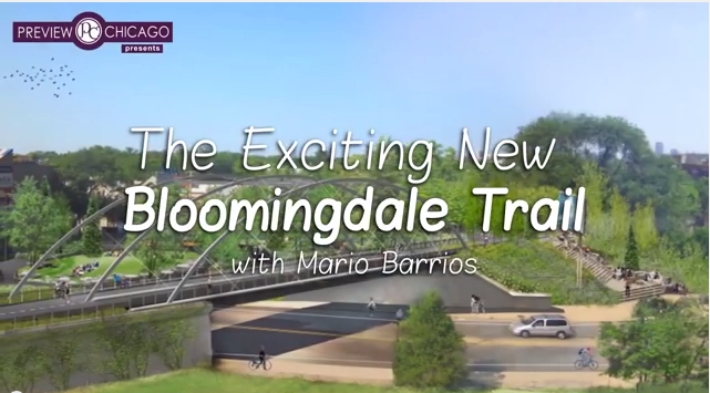 The Blooomngdale Trail
Bloomingdale Trail and Park
According to the City of Chicago:
CDOT, along with numerous community partners, is building the Bloomingdale Trail and Park– a multi-use linear park that will be the first of its kind in Chicago.
The trail and park will run along an unused, elevated rail line along Bloomingdale Avenue (approximately 1800 North) from Ashland (1600 West) to Ridgeway (3732 West).
Stretching 2.7 miles through four vibrant Chicago northwest side neighborhoods, the conversion of the elevated Bloomingdale Line into a trail and park provides unprecedented connections to and among these communities.
The future Bloomingdale Trail and Park runs through several vibrant communities along Bloomingdale Avenue, adjacent to numerous private properties, and crosses over major arterials, an historic boulevard, bus and bicycle routes, and the CTA Blue Line.
The Framework Plan builds on this unique experience, blending a safe and attractive trail, accessible to all, uninterrupted by motor vehicles, and designed for all users from children to seniors, with thirteen acres of open space to create a place to play, commute, and relax.
CDOT and its partners from the Chicago Park District, the Department of Housing and Economic Development, the Department of Cultural Affairs and Special Events, The Trust for Public Land, The Friends of the Bloomingdale Trail, and, most importantly, the community, established a set of guidelines to design, implement, and manage a local trail and park with global appeal in the heart of Chicago’s neighborhoods.
Click on the link below for an overview of the project, its history and frequently asked questions.
Bloomingdale Trail–History, Background and Frequently Asked Questions


